Search Investigations
searchinvestigations.org
Family Update
Search Investigations initiated drone and ground search operations targeting the ridgeline identified from earlier aerial imagery, along with egress routes to the south and southwest and the immediate surrounding areas. All search areas were defined using the Lost Person Behavior model — the same evidence-based framework used by search and rescue teams nationwide — combined with AI-powered image analysis and careful review of all available evidence.
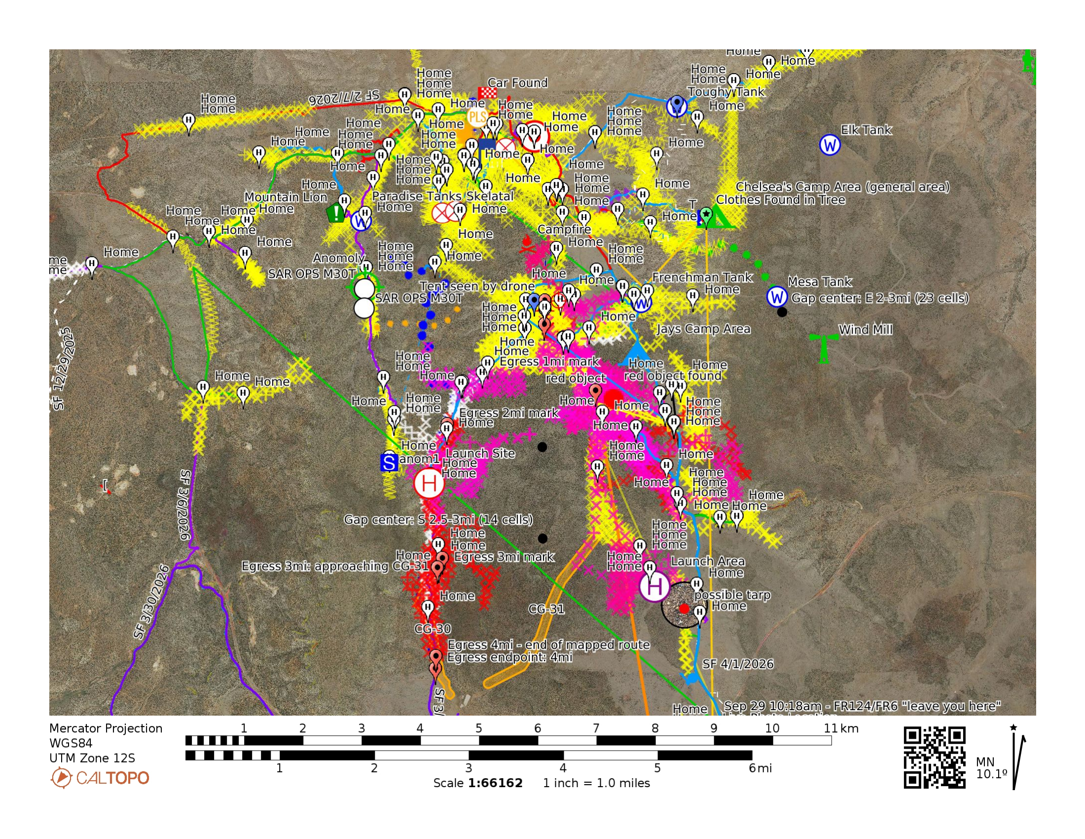
Search area map — CalTopo overlay showing tracked routes, markers, water sources, and areas of interest.
Searched the primary area near where a shelter and a person were identified on a ridgeline. Covered the main ridgeline, surrounding terrain, and established GPS tracking for all routes. 10 search tracks logged.
Expanded coverage across the full ridge system. Deployed drone (DJI M30T) for aerial mapping, capturing high-resolution photos and video to document terrain and identify areas of interest. 11 ground tracks logged.
Reviewed all collected drone imagery and videos to detect anomalies and developed the next-phase search plan. Cross-referenced aerial footage with terrain mapping to identify priority areas and coverage gaps for remaining search days.
Continued targeted search along ridgelines and washes. Documented the full line of sight from the rock on the ridgeline where the person was spotted — an approximately 180-degree view of the surrounding terrain. Continued drone flights at varying altitudes while expanding coverage along egress routes to the south and southwest.
Search expanded southward from the ridge into the wash system and descending ridgelines, which branch into three separate paths. Thousands of images captured for analysis.
Continued expanding coverage southward along identified travel corridors. Additional drone flights targeting remaining gaps. All imagery queued for pixel-level analysis, including color-match detection for known items and anomaly detection to flag anything visually out of place in the terrain.
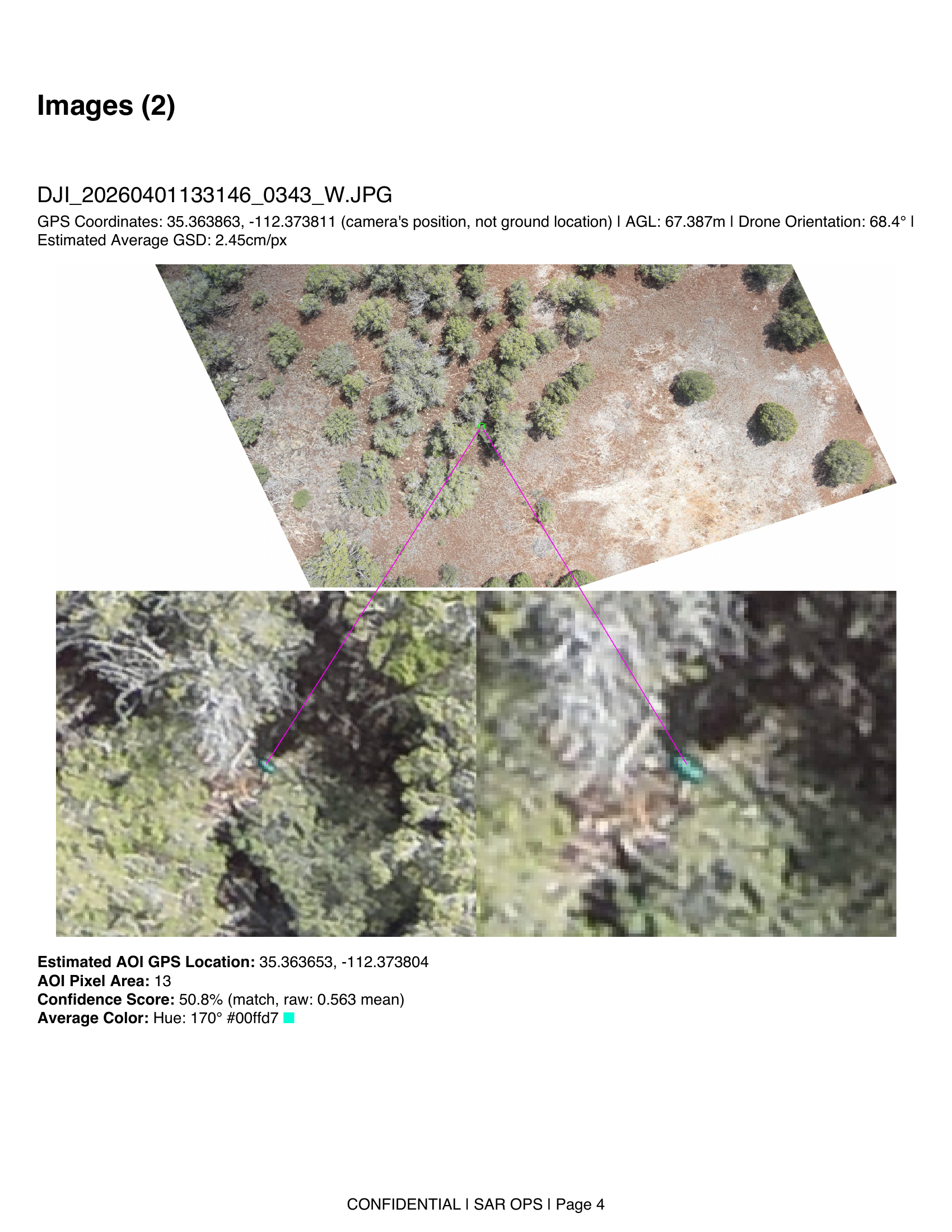
Below is an example of how the ADIAT detection system works — scanning a drone image at pixel level to identify objects matching the target color, then zooming in to isolate the area of interest for ground follow-up.
We used a combination of established search and rescue methods and modern technology to cover as much ground as possible, as thoroughly as possible.
We're using specialized detection software called ADIAT that scans every drone image for the exact color of Chelsea's tarp. The system can identify small color-matched objects even when partially hidden under tree cover.
All 84,000 images (cumulative since Dec 2025) are being processed. Initial results have flagged areas of interest that will be investigated on the ground.
A second AI system called Eagle Eye reviews every image for anything that looks out of place in the natural landscape — unnatural shapes, color irregularities, or signs of human presence.
All drone footage has been run through this system. Every flagged item is being cross-checked with the color detection results to make sure nothing is missed. All imagery will be double-reviewed through both systems.
Every step of the search is tracked and mapped in real time using CalTopo, a professional-grade mapping platform. This includes all 259 search routes, 251 markers, water sources, and areas of interest. The live map can be viewed here:
This shows how thoroughly each distance ring from Chelsea's camp has been searched:
| Area | Status |
|---|---|
| Ridgeline south and southwest of newly identified area of interest | Thoroughly searched |
| Immediate area around car (PLS) | Thoroughly searched |
| MK Tank (primary water source) | Thoroughly searched |
| Frenchman Tank | Well covered |
| Paradise Tanks area | Moderately covered |
| Primary forest roads (FR 6, FR 124) | Covered |
| Southern wash system (0–2 mi) | Partially covered |
| Southern corridor (2.5–5 mi) | Needs more coverage |
| Mesa Tank (east) | Barely searched |
| Elk Tank (northeast) | Not yet searched |
Beyond the physical search, we conducted digital and investigative work to support the effort.
Overall assessment: Based on the evidence available and the investigation to date — including the absence of any financial or digital activity — everything remains on the table. However, my investigative opinion is that the most likely scenario is that Chelsea remains in the forest. That said, as an investigator I will follow any and all evidence wherever it leads and continue to pursue every lead with merit.
A foreign SIM card was inserted into Chelsea's iPhone at some point after her disappearance. Our investigation into tracking the device through its IMEI ultimately reached a dead end — due to EU privacy regulations, the software used to log activation attempts does not retain or provide access to data involving foreign SIM cards. This remains one of the most significant unanswered questions in the case.
In the months leading up to her disappearance, Chelsea shared several posts on social media expressing a desire to go out into the wilderness. These posts are consistent with someone who was planning or contemplating an extended time in nature.

Post shared by Chelsea on Facebook, July 14, 2023
It is my investigative belief that this was an intentional trip with a purpose behind it. A Shell gas station receipt recovered from Chelsea's belongings references "Blondie" and "Roz" — with "Blondie" being a name Chelsea used to refer to Nick. This detail, combined with the deliberate nature of her preparations, the supplies she purchased, and her social media posts, supports the conclusion that Chelsea planned this trip in advance and set out with intent.

Shell gas station receipt, Clover Hill Shell, Williams AZ — 9/28/23 — with Chelsea's handwritten notes
We have requested helicopter footage from the initial search and rescue operations (Oct 6–7, 2023) from the Coconino County Sheriff's Department. This footage could help verify whether the individual and blue shelter observed by drone on the ridgeline were present at that time, which would be a critical piece of corroborating evidence. We are still awaiting a response.